| Author |
Message |
![[Post New]](/gforum/templates/default/images/icon_minipost_new.gif) 30/12/2006 22:57:31
|
eagereyes
Joined: 12/12/2006 17:42:56
Messages: 2
Location: Charlotte, NC
Offline
|
This may be slightly off topic, but I am sure somebody here will be able to point me in the right direction.
I am drawing a map of sorts (it's called the ZIPScribble Map, simply connects ZIP codes in ascending order), and have absolutely no clue how these projections work. I am using the NetCDF classes to do the projection, but the images I get do not look right.
Here is what I get when I do a UTM projection for the US, with equal scaling of the values in both directions:

This is a bit of surprise to me, because I thought that the projection would take care of all the transformations, and give me coordinates that I could just use on the screen directly. But anyway, I added a correction factor of tan(centerLatitude) to compress the image a bit, and this is what I got:

Better, but still does not quite look like this one from Wikipedia:

What is more, my correction messes up some countries like Austria (which looks about twice as high as it should be), while others (like France) look good.
I know that there is no "correct" projection, but what would be considered the common one? How do you correct for the vertical scale, and why is that even necessary?
Many thanks and a Happy New Year!
Robert
|
EagerEyes.org |
|
|
 |
31/12/2006 14:57:36
|
marc
Joined: 08/12/2005 07:39:47
Messages: 4416
Offline
|
Hi Robert
I think the Mercator projection can be considered a common one. GoogleMaps for instance is using it.
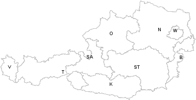
Geonames too is using the Mercator projection. Austria will look like this :
and the US :
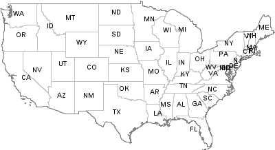
Note the straight line for the US-Canadian Border.
All countries and continents in Mercator projection are here : http://www.geonames.org/country-borders.html
a Happy New Year.
Marc
|
 |
|
|
|
02/01/2007 04:21:38
|
eagereyes
Joined: 12/12/2006 17:42:56
Messages: 2
Location: Charlotte, NC
Offline
|
Thanks, Marc! I apparently screwed around too much with my "corrections", now that I am back to the Mercator and removed all the other stuff, it suddenly works perfectly.
|
EagerEyes.org |
|
|
|
|
|

